 |
| Cycle Route |
| Sun | Mon | Tues | Wed | Thur | Fri | Sat |
| June | ||||||
| 14 Day 0 | 15 Day 1 | 16 Day 2 | ||||
| 17 Day 3 | 18 Day 4 | 19 Day 5 | 20 Day 6 | 21 Day 7 | 22 Day 8 | 23 Day 9 |
| 24 Day 10 | 25 Day 11 | 26 Day 12 | 27 Day 13 | 28 Day 14 | 29 Day 15 | 30 Day 16 |
| July | ||||||
| 1 Day 17 | 2 Day 18 | 3 Day 19 | 4 Day 20 | 5 Day 21 | 6 Day 22 | 7 Day 23 Orkney |
| 8 Day 24 Orkney | 9 Day 25 Orkney | 10 Day 26 Orkney | 11 Day 27 Orkney | |||
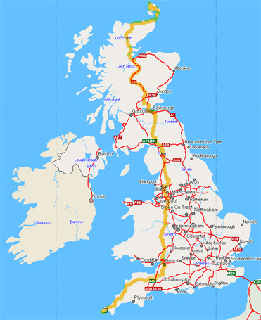
Our route was a combination of the "Bed and Breakfast" route of the CTC organization and parts of the National Cycle Network, particularly in the South West of England and in Scotland, together with a few shortcuts since the NCN routes often involve long detours to avoid quite short distances on A-roads, or even potentially busy B roads. Almost all of the route was on minor back roads, or the special cycle paths of the NCN. The NCN off-road routes were particularly useful to get through the only two large cities on the route - Bristol and Edinburgh. Since the train services in Scotland do not allow tandems (bikes are OK), even on the special Wick to Inverness cycle van, how to get back from John O'Groats presented a quandary. In the end we decided to take the passenger ferry over to Orkney, and then take the overnight car ferry from Kirkwall to Aberdeen, and rent a car there. This worked out very well, and we spent the 5 extra days doing some cycling around Orkney.
The path we took, including the Orkney tour, is shown on this Google map (or this version with associated photos). This is the actual track downloaded from my GPS, processed with GPSBabel and GPS Visualizer.1 You can enlarge the map to see the details of the route. This GPX file of the track might be useful for plotting in other mapping programs.